


Toxic Turquoise: New Mexico’s Latest ‘Map’ Unveils a Deeper Environmental Rot
POLICY WIRE — Santa Fe, N.M. — It started, as many things do, with a flicker of ambition and the promise of transparency. Another state agency, in this case New Mexico’s Environment Department...

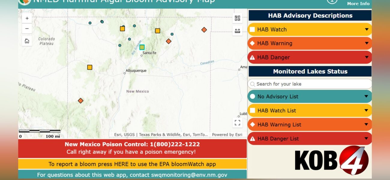
POLICY WIRE — Santa Fe, N.M. — It started, as many things do, with a flicker of ambition and the promise of transparency. Another state agency, in this case New Mexico’s Environment Department (NMED), has unfurled a new digital solution—an interactive map, no less—to what feels like a decidedly analog, even primordial, problem: Mother Nature’s increasingly toxic revolt. But a map, however sleek, can’t wash away the pea-green scum, nor the unsettling reality it signifies for the Land of Enchantment’s lakes and, by extension, its struggling tourist economy.
Gone are the carefree days of summer dives into pristine waters. Now, you’d be wise to consult the NMED’s Harmful Algal Bloom (HAB) advisory map before even packing the cooler. Because seven of New Mexico’s recreational lakes are already flagged—some on ‘watch,’ others on full-blown ‘warning’—before the summer sun has truly begun its annual scorched-earth campaign. This isn’t just about a bad swim; it’s a symptom. And for folks who rely on these waterways for their livelihood or simple respite, that symptom feels a lot like a prognosis.
The state promises weekly updates, from July through November, as fresh monitoring data rolls in. A bureaucratic gesture, certainly. But it also paints a bleak picture of extended risk. HABs, for the uninitiated, aren’t some exotic strain of aquatic illness; they’re an overgrowth of specific algae, often spurred by agricultural runoff and warmer temperatures (climate change, anyone?). They manifest as ghastly films of blue, bright green, brown, or red. Sometimes it looks like floating grass clippings; other times, a thick, nauseating paint. They don’t just smell bad; they can pose serious health risks to people — and critters alike.
A ‘HAB Watch Advisory’ basically means there’s trouble brewing. We’ve got visual confirmation something nasty is cooking. But a ‘HAB Warning Advisory’? That means measured toxins have already breached safety thresholds. That’s not a maybe; that’s a stay-the-hell-out order. Current victims include Quemado Lake, Clayton Lake, and Lower Charette Lake—all under full warning. Then you’ve got El Vado, Bluewater, Eagle Nest, — and Santa Cruz lakes under watch. It’s a list that reads like a mournful roll call for summertime fun.
But what exactly does a map accomplish beyond the obvious public health alert? “We’re providing New Mexicans with the most current data to make informed decisions about recreating safely,” stated James McCaffrey, Deputy Secretary for the New Mexico Environment Department, during a recent press brief (and, let’s be honest, probably a heavily rehearsed one). “It’s about transparency. We don’t want anyone taking a chance with these potent toxins.” It’s hard to argue with transparency, yet one can’t shake the feeling it’s a defensive posture rather than an offensive strategy.
Governor Michelle Lujan Grisham (D), ever the politician attuned to the state’s natural splendors, chimed in, saying, “Our beautiful lakes are one of our greatest assets. We’re going to protect them, — and part of that protection is empowering our citizens with information.” Fine words. But sometimes, empowerment means addressing the root causes, not just pointing to the ugly consequences on a digital display.
Because the issues here run deeper than surface-level warnings. A 2018 study published in the Environmental Science & Technology journal estimated the annual economic losses from harmful algal blooms in the U.S. alone at up to $4.6 billion, impacting everything from commercial fishing to tourism. That’s a staggering hit. And you’ve gotta wonder how long New Mexico’s relatively small economy can keep absorbing such blows without real remediation.
📄 POLICY WIRE WHITEPAPER PUBLISHED: PAKISTAN'S NATIONAL SECURITY POLICY PRIORITIES
👉 READ BY CLICKING HEREYou might be asking, how does this fit into a larger global context? Well, these water quality nightmares aren’t unique to New Mexico’s deserts. They’re a stark reminder of environmental governance challenges worldwide. Think about developing nations, say in Pakistan or parts of South Asia, where millions depend directly on often-polluted water sources for drinking and agriculture. The absence of comprehensive monitoring systems, coupled with unchecked industrial and agricultural runoff, turns their already precarious water situation into a public health catastrophe many times over. Where a map here gives a warning, there’s often just sickness — and death.
What This Means
This new map, while a public safety good, represents a sort of tactical retreat. The state isn’t preventing the blooms; it’s merely warning you where they’re. Politically, it lets officials say they’re ‘doing something,’ pushing the onus onto the public to ‘check before you swim.’ But for towns like those surrounding Eagle Nest or Quemado, dependent on summer tourism dollars, this isn’t just an advisory; it’s an economic anchor being dragged down. It implies a broader failure of policy — one that hasn’t adequately addressed the inflow of nutrients (think fertilizers, wastewater) fueling these green, gelatinous monsters. Reclaiming environmental stability often requires far more than just better data visualization. The unspoken truth is that these blooms aren’t some natural, unavoidable phenomenon; they’re largely man-made problems requiring systemic fixes, not just interactive PDFs.
Economically, if this trend continues—and without aggressive policy changes, it will—expect a hit to property values around these now-tainted recreation spots. Water scarcity — and quality are global battlegrounds; New Mexico just got its digital front line. We’ve seen other regions grappling with environmental degradation and its ripple effects, like Germany’s struggles with recurring floods, which underscore how natural events can become crises through a lack of preventative infrastructure and shifting climates. People are encouraged to report suspected blooms through the U.S. Environmental Protection Agency’s BloomWatch program—another layer of decentralized vigilance, another responsibility off the state’s plate. They’re telling you to stay out if it smells bad, or looks scummy. Common sense, you’d think. But we’ve come to a point where even common sense needs an official advisory to be taken seriously. That’s where we’re: a digitized wilderness, charted not by discovery, but by danger. And it’s not looking pretty, metaphorically or literally.