



Hurricane Polo Path: Southwest U.S. Braces for Flooding After Mexico Landfall
Hurricane Polo moves toward the U.S. after hitting Mexico. Over 30 million people face flash flood risks from Arizona to Iowa. Track the storm's impact.

POLICY WIRE — Washington, D.C. — The National Hurricane Center reported Tuesday that Hurricane Polo is tracking toward the southwestern United States following its destructive path across Mexico.
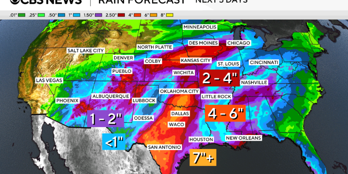
More than 30 million residents spanning from Arizona to Iowa are currently under threat of flash flooding. In southern New Mexico, heavy rainfall has already inundated roadways, leaving motorists stranded until floodwaters subsided.
Polo is currently traversing Mexico’s Baja California Sur in a northwesterly direction at a speed of approximately 10 miles per hour. Forecasters anticipate the storm will maintain this trajectory while significantly accelerating throughout Tuesday morning.
The storm’s center is projected to traverse the Gulf of California before making a secondary landfall in Sonora, Mexico, late Tuesday morning. It is expected to reach the vicinity of El Paso by Wednesday morning.
Upon reaching El Paso, the system is forecast to carry winds of roughly 35 miles per hour, gradually losing strength as it pushes further into the Southwest. Flash flood watches remain active for a vast region stretching from Phoenix, Arizona, to Des Moines, Iowa.
📄 POLICY WIRE WHITEPAPER PUBLISHED: PAKISTAN’S NATIONAL SECURITY POLICY PRIORITIES
Over 14 million Americans are at risk of major flooding, with some locations potentially receiving up to two inches of rain per hour. The National Weather Service Prediction Center has warned of a significant flash flood threat extending from the Four Corners Region into the Central Plains.
Precipitation is expected to persist through Wednesday in southern Colorado and along the I-35 corridor. Texas, including the Dallas area, may experience rain through Thursday, with some regions bracing for more than seven inches of accumulation.
Hurricane Polo previously fluctuated between Category 4 and Category 5 intensity, fueled by extreme rapid intensification. The storm saw wind speeds surge from 45 mph to 150 mph between Sept. 21 and Sept. 22, a shift the NHC described as truly remarkable.
At its peak over the weekend, the storm reached maximum sustained winds of 180 mph, tying 2009’s Hurricane Rick as the third-strongest on record for the region. Its central pressure ranks it as the second-strongest hurricane in Eastern Pacific history, trailing only 2015’s Hurricane Patricia.
Separately, Hurricane Nolo impacted Hawaii’s Big Island over the weekend with heavy rain and wind. Experts attribute the current surge in tropical cyclone activity to warmer waters, moist air, reduced wind shear, and unusually strong El Niño conditions.
Reporting by Policy-Wire (PW)